Our Towns
Shire of Merredin Townships
Burracoppin
Distance from Merredin - 25kms east on the Great Eastern Highway.
Facilities - Wheat siding, Burracoppin Hotel, recreation facilities.
In the early quarter of the 1900's Burracoppin was the main depot for the Rabbit Proof Fence. All gates through the fence and wells for the fence runners (those who look after the fence) were numbered from this town. For example, the Ten Mile gate was ten miles north of Burracoppin.
Hines Hill
Distance from Merredin - 20kms west on the Great Eastern Highway.
Facilities - Wheat siding, TransWA station (pick up and set down if bookings made), Hines Hill Tavern, historic weighbridge.
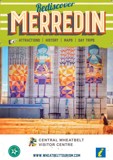
Merredin
Merredin is situated approximately 260 kilometres east of Perth (the capital city of Western Australia) and is the major commercial and retail centre for the eastern Wheatbelt.
It is also a regional base for a range of Government agencies and services. It is an area with high employment and extensive community involvement.
Located on the Great Eastern Highway and having the benefit of railway facilities (Merredin is serviced daily by the TransWA Prospector train) it is convenient to find by road and rail.
For more information about attractions, history, and day trips, download the brochure below or head to Central Wheatbelt Visitors Centre.
Muntadgin
Distance from Merredin - 56kms south east of Merredin, off the road to Narembeen.
Facilities - Wheat siding, Muntadgin Hotel with accommodation and meals available, Playground and Park Picnic area, Golf Course and recreation facilities.
The town celebrated its 75th Anniversary in 2005.
Shire of Merredin Localities
- Goomarin
- Korbel
- Nangeenan
- Nokanning
- Norpa
- Nukarni
- South Burracoppin
- Tandegin
If you have additional historical information on the localities within the Merredin Shire and would like to submit it, we would welcome your communication.